


Andaman Travel Tips 2026: What No One Tells You About Ferries & SIMs
Discover the ferry booking tricks, SIM card recommendations, and practical island travel tips that every Andaman traveler should know before visiting.
Discover the natural wonders of Baratang Island, from mangrove creeks and limestone caves to the fascinating journey through the Jarawa Reserve.

When most travellers begin planning a holiday in the Andaman and Nicobar Islands, their minds immediately turn toward classic beach destinations. They picture stepping off a ferry onto the fine sand of Havelock Island, swimming in clear turquoise lagoons, and watching the sunset over calm western horizons. These coastal spots form the backbone of regional tourism for good reason, offering a comfortable blend of resort relaxation and marine activities. However, if you venture northward from the capital city of Sri Vijaya Puram, which is historically and commonly searched by travellers as Port Blair, the character of the archipelago changes dramatically. Introducing Baratang Island into your holiday itinerary shifts the experience away from sunlit beaches and moves it toward overland exploration, dense tropical forests, winding mangrove waterways, and unusual geological formations. A day trip to Baratang is not something you casually squeeze between afternoon naps. It requires an early departure, a long road drive, a government-regulated convoy through a protected forest reserve, a vehicle ferry crossing, a mangrove boat ride, and a walk through ancient limestone caves. Baratang proves that an Andaman holiday can be just as much about discovering the raw interior of the islands as it is about lounging on the coast.

Geographically, Baratang Island occupies a strategic central position within the Andaman chain, acting as a natural land bridge connecting the southern districts around the capital with the remote northern territories of Middle and North Andaman. Official tourism information published by the Andaman & Nicobar Tourism Department places Baratang approximately 100 to 110 kilometres north of Sri Vijaya Puram by road. Because it sits nestled between dense forest reserves and sheltered marine straits, reaching it requires a multi-stage transit journey that combines highway driving, water crossings, and local boating. This geographical isolation is precisely what keeps the destination feeling wild and distinct from the more commercialized resort areas further south.
Comparing Baratang to popular southern destinations highlights the remarkable diversity found across the island chain. While islands like Swaraj Dweep are celebrated for beachfront hotels, water sports, and scuba diving, Baratang offers an entirely different style of travel. Its primary attractions do not revolve around swimming bays or commercial entertainment. Instead, the island draws its appeal from natural geological phenomena, quiet mangrove creeks, remote forest roads, and an offbeat atmosphere that rewards travellers who appreciate earth science and raw geography. The official tourism administration includes Baratang among its primary nature and adventure destinations, highlighting its role in showcasing the interior landscapes of the territory.

The overland route heading north from the capital toward Baratang involves travelling along the regional highway network, known locally as the Andaman Trunk Road. This road passes directly through a sensitive territorial zone officially designated as the Jarawa Tribal Reserve. Official administrative guidelines published by the Andaman & Nicobar Administration establish strict protocols governing this 49-kilometre forest stretch. Vehicles travelling through the reserve must do so as part of a regulated, police-escorted convoy system. This system ensures that travel is organized into specific time windows rather than allowing open, uncontrolled movement through protected territory. The convoy system exists to safeguard the health, privacy, safety, and cultural autonomy of the indigenous Jarawa community, who have inhabited these forests for generations.
Because the Andaman Trunk Road cuts directly through a protected indigenous territory, travellers must understand that they are guests passing through a regulated area. The reserve is not a safari park, and the Jarawa people are not a tourist attraction. Under strict government regulations, all visitors, drivers, and tour participants must adhere to zero-tolerance rules while inside the reserve. It is strictly prohibited to stop vehicles to look for people, take photographs, record videos, attempt any form of communication, approach individuals, offer food, toss gifts or wrappers out of vehicle windows, or try to attract attention in any way. Respecting these rules is both a legal requirement and an essential ethical obligation for every person travelling along the route.
Responsible tourism requires recognising that certain spaces are meant for preservation rather than commercial exploitation. The Jarawa Tribal Reserve exists to protect an indigenous population that has the right to live free from outside interference, disruption, and cultural intrusion. Viewing the journey through the reserve simply as a regulatory hurdle to reach the limestone caves misses the point entirely. Respecting the privacy and safety of the community demonstrates basic human decency and supports the broader effort to protect the cultural heritage of the Andaman Islands. Travellers who cannot approach the journey with respect and strict obedience to local laws should reconsider adding Baratang to their itinerary.
Preparing for a Baratang day trip means accepting an early morning start from Sri Vijaya Puram. Vehicles gather at the designated southern checkpoint before the regulated convoy departs northward. The drive takes you deep into dense tropical rainforests, where tall hardwood trees arch over the road and sunlight filters down through thick foliage. Once the convoy reaches the entry point of the protected reserve, all vehicles travel together under police supervision until they exit the northern boundary. While waiting for convoy timings can occasionally introduce waiting periods, the journey offers a peaceful look at the untouched interior of the island before the road leads out toward the coast.
Upon exiting the forest reserve, the Andaman Trunk Road leads travellers toward the Middle Strait area, where land transport must temporarily transition to water transport. Here, vehicles drive directly onto a government passenger and vehicle ferry to make the short aquatic crossing across the strait. This ferry link connects the southern road network with Baratang Island itself. Standing on the deck of the ferry provides a refreshing sea breeze and a clear view of the surrounding mangrove-lined shores, marking the final logistical step before you arrive on the island and prepare for your excursion into the limestone caves.

Once you arrive on Baratang Island and make your way to the designated departure jetty, the adventure shifts from asphalt roads to quiet water channels. Visiting the famous limestone caves requires taking a scenic boat ride through dense mangrove-lined waterways. The official tourism department includes this mangrove boat journey as a standard, essential part of the Baratang excursion. As the local boat pushes away from the dock, it enters a narrow, winding creek where the water surface is remarkably calm. The engine hums quietly, and the boat moves at a relaxed pace through a green corridor of tangled mangrove roots and overhanging branches.
These coastal wetland forests play a vital role in maintaining the ecological health of the islands. Official environmental guidelines from the Ministry of Environment, Forest and Climate Change note that mangroves form an essential protective buffer between land and sea. Their sprawling root systems absorb the force of incoming tidal surges and coastal waves, preventing severe erosion along island shorelines. Furthermore, these sheltered creeks serve as natural nurseries for countless species of marine life, including young fish, crabs, and molluscs. Gliding through the mangroves offers a direct look at the biological foundation that supports the wider marine ecosystem of the territory.
The boat ride through the mangrove creeks provides a striking atmospheric contrast to the dusty, forest-lined highway drive. The air feels cool and humid, carrying the earthy scent of wet soil and damp vegetation. The water surface around the boat acts like a dark mirror, reflecting the heavy green canopy above. Because motorised boats must navigate the narrow turns slowly, there is no rushing here. You sit back and watch the intricate root systems slide past, listening to the occasional call of a wading bird or the splash of a fish. It offers a meditative, quiet interlude before you reach the landing point for the cave walk.
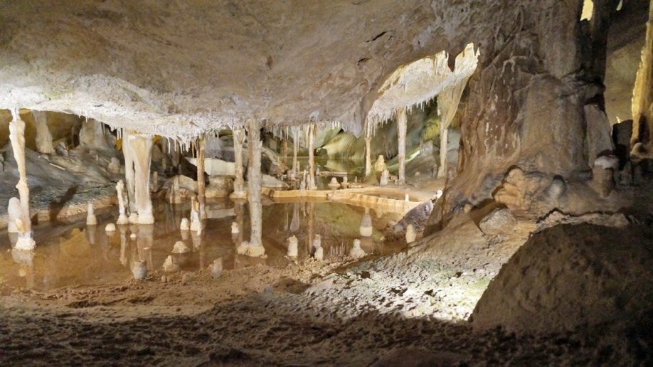
The limestone caves represent the primary geological highlight of any Baratang trip. Limestone is a sedimentary rock composed largely of calcium carbonate, formed over immense spans of geologic time from the compacted skeletal fragments of ancient marine creatures. Over thousands of years, slightly acidic rainwater seeps down through cracks and fissures in the overlying forest soil, slowly dissolving the soluble rock and carving out hollow chambers, narrow tunnels, and dramatic mineral deposit formations. Exploring these caves reveals a quiet subterranean world sculpted entirely by natural chemical processes and the patient passage of time.
Reaching the cave entrance involves a multi-stage transition. After completing the road journey, the forest convoy, the Middle Strait ferry, and the mangrove boat ride, the boat docks at a simple wooden landing jetty near the mangrove edge. From there, visitors continue the journey on foot, following a natural walking trail that leads from the coastal mangrove fringe into the shaded forest interior toward the cave opening. Local signage and forest department markers guide visitors along the correct path, ensuring everyone stays within the authorized sightseeing zone.
Stepping inside the limestone cave system offers an instant, refreshing escape from the humid tropical heat of the jungle outside. The interior walls feature rugged, uneven textures, damp surfaces, and intricate mineral formations that have built up over centuries. Visitors walk carefully through the dim chambers, observing natural rock pillars, hanging stalactites, and mineral textures shaped by dripping moisture. Because natural cave floors can be uneven, damp, and slippery, visitors must watch their footing closely. It is an authentic, unpolished natural experience rather than a developed theme-park attraction with artificial lighting and concrete pathways.
Limestone formations grow at an extraordinarily slow rate, measured in fractions of a millimetre per year. The oils and natural moisture present on human skin can permanently stain the mineral surfaces, interrupting the delicate chemical processes that allow stalactites and stalagmites to form. Visitors must avoid touching, scratching, leaning against, or breaking off pieces of rock to take as souvenirs. Preserving the physical integrity of the caves ensures that future travellers can experience the same untouched geological wonder.

In addition to the limestone caves, Baratang is widely known for its fascinating cluster of natural mud volcanoes. A mud volcano is a geological landform created by the emission of pressurized mud, gases, and water from deep beneath the earth's crust. Unlike dramatic mountain volcanoes that erupt with molten lava and ash, mud volcanoes operate through a much cooler, slower process driven by tectonic pressure and trapped underground methane pushing fine sediment upward toward the surface. Visitors walk along a designated boardwalk to view small, bubbling grey mud mounds and shallow pools, observing an active geological phenomenon up close.
Baratang is almost universally visited as an intensive day trip from Sri Vijaya Puram. Official tourism itineraries outline one-day programmes that start before sunrise and return by evening. However, because the journey involves significant road distances, regulated convoy timings, a vehicle ferry crossing, a boat ride, and walking trails, it demands a major commitment of energy. Travellers should expect an early start and keep their schedule flexible, recognizing that a Baratang excursion is an active expedition rather than a leisurely holiday outing.
Planning your trip is heavily influenced by regional weather patterns. Official tourism guidance indicates that the dry months spanning from October through May offer the most reliable conditions for road travel, convoy movement, boat transfers through mangrove creeks, and outdoor walking. The monsoon season brings heavy rainfall that can make forest tracks slippery, cause travel delays on the highway, and occasionally prompt temporary restrictions on boat operations. Checking current weather forecasts before setting out is essential for a smooth trip.
Dressing appropriately for a full-day forest and cave excursion prioritizes practical comfort. Wear lightweight, breathable, and loose-fitting clothing made from quick-drying fabrics to handle the humid jungle environment. Sturdy walking shoes or hiking sandals with deep treads are mandatory for navigating uneven limestone paths and muddy ground safely. Pack a reusable bottle of drinking water, sun protection, insect repellent, personal medications, and waterproof protection for electronic devices. Furthermore, the official tourism department states that valid original government-issued photo identification is required for Indian nationals at the Jirkatang checkpoint, so keep your ID easily accessible.
Coordinating complex road transfers, boat hires, weather monitoring, and regional sightseeing requires professional logistical support. At Andaman Bliss, we help travellers design seamless, customized holiday itineraries that cover every corner of the archipelago. Whether you want to book a dedicated Baratang Island tour, arrange comprehensive Andaman tour packages, or secure a fully customised Andaman itinerary, our local team handles your arrangements reliably. To explore fully coordinated travel options, you can review our complete collection of Andaman sightseeing guides and let us help you design your ideal island getaway.
Discover the ferry booking tricks, SIM card recommendations, and practical island travel tips that every Andaman traveler should know before visiting.
Visit Cellular Jail and Ross Island to uncover the remarkable history of Kala Pani, India's freedom movement, and Andaman's colonial heritage.
Trek through tropical forests, race across the sea by speedboat, or explore the ocean floor with sea walking—find the best Elephant Beach experience for your Andaman trip.

